Darby and Cobbs Creek Study
Every four weeks, Community Science Volunteers visit sites throughout the Darby and Cobbs Creek Watershed to collect data on the following water chemistry parameters:

The Data Tell a Story.
If you live in the Darby or Cobbs Creek watershed, you play an important role in protecting local water quality. Since 2021, the Darby & Cobbs Creek Community Science Monitoring Program (DCCCS), has found that elevated chloride levels are one of the most consistent water quality concerns in local streams. Elevated chloride levels are linked to road salt application ahead of winter storms.
Volunteer led water testing shows year round high chloride and conductivity levels at all sites, even during dry periods. This means salt applied in winter doesn’t disappear—it accumulates in soil and groundwater, slowly leaching into streams long after the snow has melted.

DCCCS Volunteers collect the following data every four weeks to understand the complex relationship between the land, water, and history of the Darby and Cobbs Creek Watershed:
The Data Shows a Complicated System.
The history of intensive land use in the Darby and Cobbs Watershed, including three nearby superfund sites and increasing impervious surface cover as these streams flow downstream to John Heinz National Wildlife Refuge, has resulted in a complex system, which the Pennsylvania DEP has labeled as impaired for aquatic life - meaning that most or all of these streams cannot support the full diversity of aquatic life that should be able to live in these streams.

Sources of impairment include urban runoff, combined storm sewer overflow, stormwater, habitat modification, siltation from erosion, and flow variability.
In a watershed that is home to over half a million people, it is crucial to understand the relationship between human activity on the landscape and the function of these waterways. The data collection efforts of DCCCS volunteers have been making great strides towards aiding that understanding and supporting the existing state wide data set.
...and the Data Shows Salt is a Problem.
Local, regional, and national trends show that streams are getting saltier, and that this issue is driven by the overapplication of road salt in the winter.
Degrades drinking water quality.
Increases corrosion of infrastructure.
Harms vegetation along roadsides and streambanks.
Stresses freshwater organisms such as mayflies, stoneflies, caddisflies, and freshwater mussels — species that are essential to healthy stream ecosystems.
Disrupts natural nutrient cycles.
Over time, the buildup of salt:

The Land and Water
There is a relationship between land use and water quality that has been shown in the data set:
-
as impervious surfaces increase, so do the negative impacts on water quality.
-
as forest cover increases, regardless of impervious surfaces, water quality improves.
This is reflected in chloride, conductivity, and water temperature data, but the relationship gets a little tricky as you move further downstream towards towards where the Darby and Cobbs Creeks meet.

Water Temperature
Water Temperature is an important water chemistry parameter as it determines the amount of available dissolved oxygen in the waterway - warm water can hold lower concentrations of dissolved oxygen, which means less is available for sensitive stream wildlife.
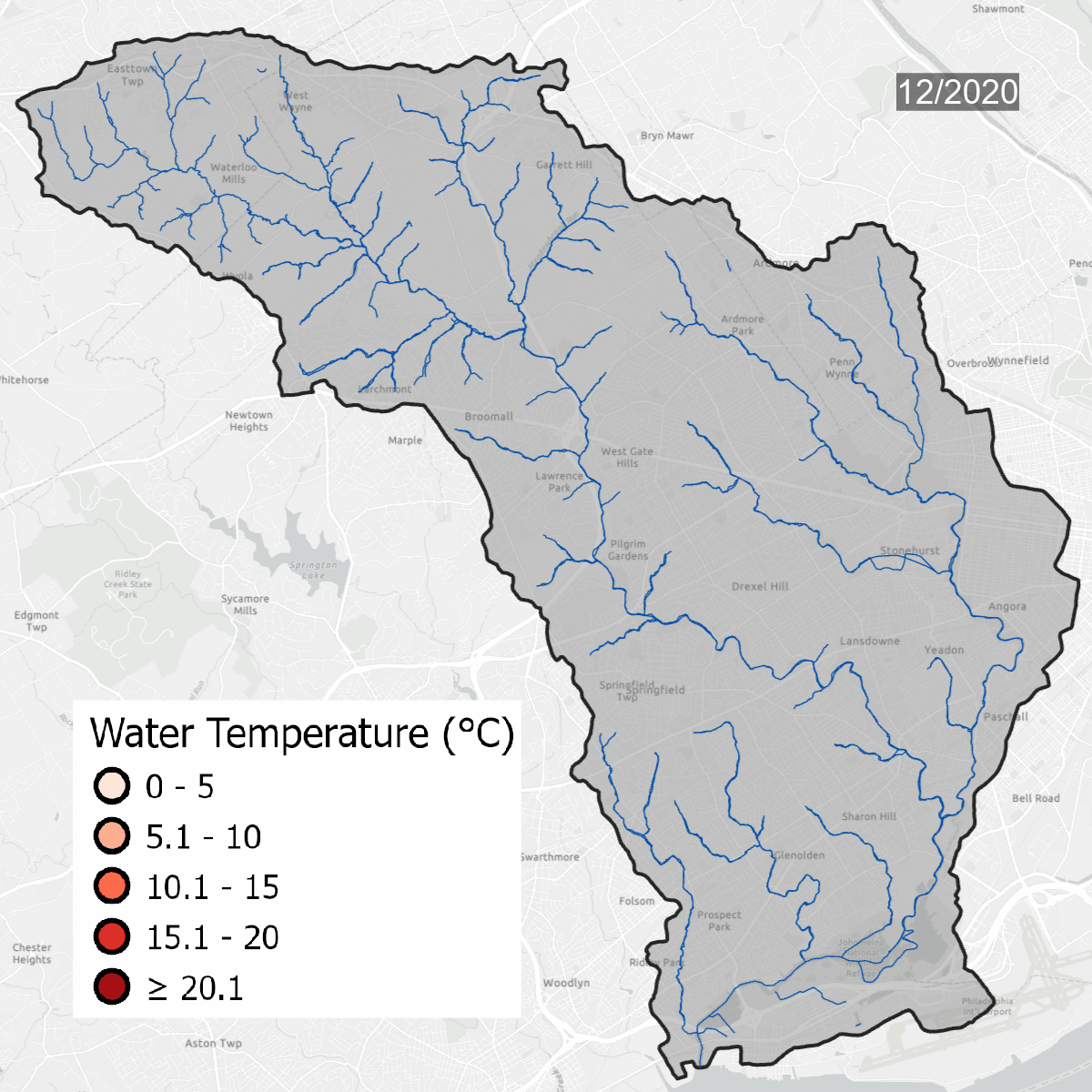
Water temperatures at all sites over time. Warmer water temperatures have darker colors, cooler water has lighter temperatures. Note the seasonal change at sites.

This is the same data that is on the map above, but laid out over the course of several years, which shows seasonal changes - with warmer water in the summer and colder water in the winter. Graph updated with data through September 2023.
Water temperature is one of the major thresholds that the Pennsylvania Department of Environmental Protection uses to determine if a waterway is healthy. Sites need to be regularly below the solid line on the graph (left) to be considered a Cold Water Fishery. As water becomes warmer, cold tolerant species begin to disappear, changing the dynamic of the waterway. Winter temperatures in the Darby/Cobbs Watershed are almost entirely warmer than the maximum temperature to be considered a Warm Water Fishery. Winter and early spring are when species are most sensitive to temperature pollution.
Conductivity
Conductivity measures the water's ability to carry an electric current, and is often used to show the impact of human activity on the landscape. Conductivity levels increase as more ions (like Chloride) dissolve in water. In the winter, the application of road salt on driveways, roads, and sidewalks drives higher levels of conductivity in waterways - while salt is not the only driver of higher conductivity, it is the major contributor in the region.
Melting winter snow and ice carries salt into streams, causing rapid increases in conductivity levels throughout the watershed. Rainstorms can cause conductivity levels to fall, as more water separates the ions, reducing the ability of the water to carry an electric current.
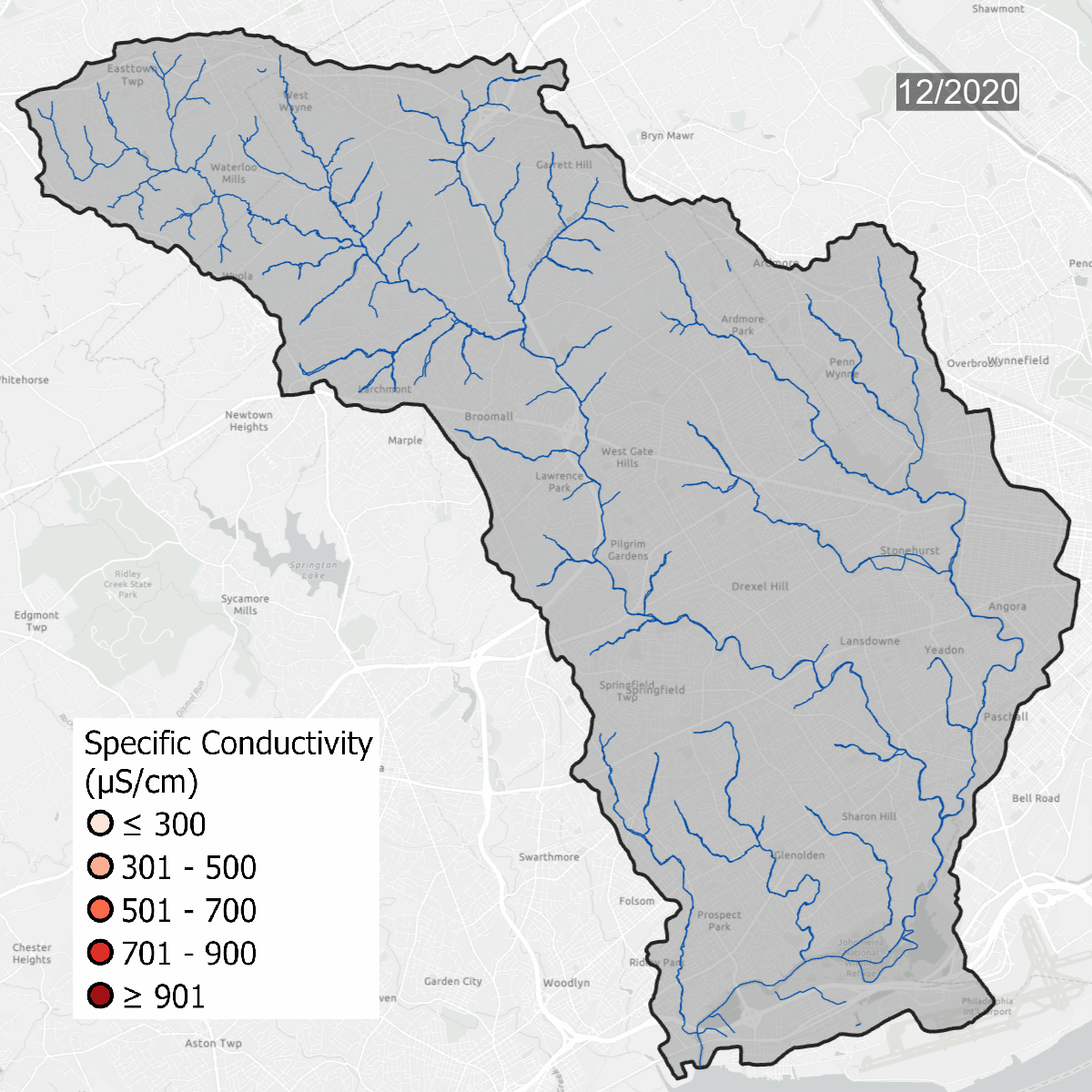

Conductivity levels at all sites over time. All sites show that conductivity levels are far above baseline, which should be between 75-90 uS/cm.
Conductivity is measured using a Hanna Conductivity meter.

This is the same data that is on the map above, but laid out over the course of several years, which shows the range of conductivity levels throughout the course of the project. Graph updated with data through September 2023.
Spikes in conductivity occur in the winter months after snow and ice melt and carry road salt into waterways. Some sites, like DCYM1 in pink, have conductivity levels that are always high due to the build up of salts and metals in the soil.
The more development on the landscape, the higher conductivity will be over time.

The Darby and Cobbs Creek watersheds become highly developed the closer you travel to the Delaware River, but any development upstream causes changes in water chemistry. Changes in the headwaters will impact the lower watershed, which is already highly influenced by a long history of landscape changes and industrial development.

Chloride
Chloride is introduced into the watershed most often through the application of road salts (usually sodium chloride, NaCl). When salt dissolves, it separates into the two elements. Chloride is very easy to test for using Quantab Chloride Strips.


Chloride concentrations over time.
- 50 mg/L is the ecological threshold for impact on wildlife
- 120 mg/L is Canada's long-term exposure limit
-
Long-term or chronic exposure means concentrations should remain below this threshold to protect most aquatic life
- 230 mg/L is the USEPA's long-term exposure limit
-
250 mg/L is when you can taste salt in water
- 640 mg/L is Canada's acute exposure limit
- The threshold that aims to protect most aquatic life from severe transient exposure like heavy salt runoff after a storm event
- 860 mg/L is the USEPA's acute exposure limit

This is the same data as presented in the gif above, but plotted out over time. Chloride levels increase in winter months, but with regular application can build up in the soil and ground water causing high levels to be present year round. The orange line is at 50 mg/L, the level where continuous exposure can impact stream life. The red line marks 230 mg/L, the USEPA's long term exposure limit. The graph updated with data through September 2023.

Chloride plotted against the amount of impervious surface on the landscape in the watershed of each site. As impervious surface increases, so does the amount of chloride in each sample.
Orange sites are part of the Darby Creek Community Science Program. Teal sites are part of the Willistown Conservation Trust's monthly water monitoring.
Chloride levels increase in relation to the amount of surfaces that do not allow for water to pass through. With more slippery surfaces, more road salt is applied in excess, washing into nearby streams and collecting in soils. Salt use is on the rise nation wide, which means more stressful conditions in waterways for sensitive life.

20 million metric tons of salt are applied to roads in the United States of America annually.
pH
pH determines how easily aquatic organisms can use nutrients and indicates how toxic pollutants may be. A pH range between 6 and 9 is ideal for aquatic life to thrive, when the range is above this (more basic) or below (more acidic), nutrients are harder to absorb and pollutants become more toxic.

